
Public Transit Analysis in ArcGIS 
Public transit is an essential part of urban life, providing access to jobs, education, shopping, healthcare, recreation, and more. ArcGIS is used to analyze the impact of traffic congestion, climate change, and the changing urban economy and population on public transit. This analysis helps to ensure that public transit remains an effective and efficient way to move people around cities. ▼
ADVERTISEMENT
Course Feature
![]() Cost:
Cost:
Free
![]() Provider:
Provider:
Youtube
![]() Certificate:
Certificate:
Paid Certification
![]() Language:
Language:
English
![]() Start Date:
Start Date:
On-Demand
Course Overview
❗The content presented here is sourced directly from Youtube platform. For comprehensive course details, including enrollment information, simply click on the 'Go to class' link on our website.
Updated in [February 21st, 2023]
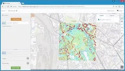
Public transit (like buses and subways) serves the people of a city by providing access to jobs, education, shopping, healthcare, recreation, and more. Traffic congestion, climate change, and the evolving urban economy and population have created a greater need than ever to understand how well transit is serving our cities. In this video series, we'll do a deep dive into tools and techniques in ArcGIS Pro for doing geographic analysis with public transit data in order understand our public transit systems and model the way they connect our communities. The bulk of the series will focus on how to use your public transit data to answer a series of essential questions: Who does the public transit system serve? How well are people served by transit? How easily can people access important destinations by transit? To answer each of these questions, we'll dive into the tools available in ArcGIS and some best practices for using them. We'll progress from simply visualizing the locations of public transit stops and lines in a map, to mapping the transit system coverage, to mapping the frequency of service available, to modeling travel by public transit in a network, to calculating job accessibility.
(Please note that we obtained the following content based on information that users may want to know, such as skills, applicable scenarios, future development, etc., combined with AI tools, and have been manually reviewed)
What skills and knowledge will you acquire during this course?
This course will provide participants with the skills and knowledge to analyze public transit data in ArcGIS Pro. Participants will learn how to visualize public transit stops and lines, map transit system coverage, map the frequency of service available, model travel by public transit in a network, and calculate job accessibility. Additionally, participants will gain an understanding of best practices for using the tools available in ArcGIS.
How does this course contribute to professional growth?
This course contributes to professional growth by providing an in-depth look at the tools and techniques available in ArcGIS Pro for analyzing public transit data. By learning how to use these tools, professionals can gain a better understanding of how public transit systems serve their communities and how to model travel by public transit in a network. Additionally, professionals can learn best practices for using the tools to answer essential questions about public transit, such as who is served by the system, how well they are served, and how easily they can access important destinations.
Is this course suitable for preparing further education?
This course is suitable for preparing further education in public transit analysis in ArcGIS. It covers a range of topics, from visualizing public transit stops and lines to mapping transit system coverage and frequency of service, to modeling travel by public transit in a network and calculating job accessibility. It provides a comprehensive overview of the tools and techniques available in ArcGIS Pro for doing geographic analysis with public transit data.
Course Provider

Provider Youtube's Stats at AZClass
Discussion and Reviews
0.0 (Based on 0 reviews)
Explore Similar Online Courses

Raspberry Pi Tutorials (Model B+)

USMLE Biostatistics Teaching (detailed)

Python for Informatics: Exploring Information

Social Network Analysis

Introduction to Systematic Review and Meta-Analysis

The Analytics Edge

DCO042 - Python For Informatics

Causal Diagrams: Draw Your Assumptions Before Your Conclusions

Whole genome sequencing of bacterial genomes - tools and applications

Deep Learning
How to create new shape file and geodatabase in ArcGIS
Start your review of Public Transit Analysis in ArcGIS