
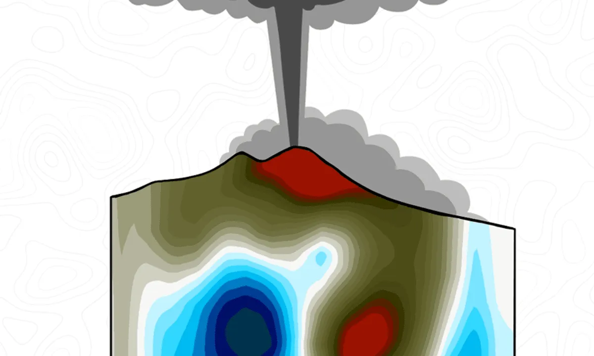
Seismic tomography: look inside the Earth 
This course provides an introduction to seismic tomography, a technique used to image the Earth's interior. Learn how seismic waves are used to create 3D images of the Earth's interior and gain insight into the structure and composition of the Earth. ▼
ADVERTISEMENT
Course Feature
![]() Cost:
Cost:
Free
![]() Provider:
Provider:
Coursera
![]() Certificate:
Certificate:
Paid Certification
![]() Language:
Language:
English
![]() Start Date:
Start Date:
28th Feb, 2022
Course Overview
❗The content presented here is sourced directly from Coursera platform. For comprehensive course details, including enrollment information, simply click on the 'Go to class' link on our website.
Updated in [March 06th, 2023]
This course, "Seismic Tomography: Look Inside the Earth," provides an introduction to the use of seismic tomography and its mathematical base. Participants will learn about earthquakes and how they start, as well as conduct experiments and go on an expedition to Kamchatka. By the end of the course, participants will have a basic understanding of seismology and how to use technical instruments and programs in practice. Complex topics are explained in simple and accessible language, making the course suitable for geophysicists, mathematicians, geologists, geochemists, petrologists, engineers, and anyone else interested in the subject. Participants will gain access to the author's research methods and scientific algorithms used by seismologists around the world. Join us for an exciting adventure!
[Applications]
Upon completion of this course, participants will be able to apply the knowledge and skills acquired to their own research and projects. They will be able to use seismic tomography to gain a better understanding of the Earth's interior, as well as to identify and analyze seismic activity. Additionally, participants will be able to use the technical instruments and programs discussed in the course to conduct experiments and analyze data. Finally, participants will be able to use the author's research methods and scientific algorithms to further their own research.
[Career Paths]
The career paths recommended to learners of this course are:
1. Seismologist: Seismologists use seismic tomography to study the structure and composition of the Earth's interior. They analyze seismic waves to determine the location and magnitude of earthquakes, and use the data to create 3D models of the Earth's interior. Seismologists also use their knowledge to develop earthquake prediction models and to assess the potential risks of seismic activity. The demand for seismologists is expected to grow as the need for accurate earthquake prediction and risk assessment increases.
2. Geophysicist: Geophysicists use seismic tomography to study the physical properties of the Earth's interior. They analyze seismic waves to determine the composition and structure of the Earth's crust, mantle, and core. Geophysicists also use their knowledge to develop models of the Earth's magnetic field and to study the effects of seismic activity on the environment. The demand for geophysicists is expected to grow as the need for accurate models of the Earth's interior increases.
3. Geologist: Geologists use seismic tomography to study the structure and composition of the Earth's surface. They analyze seismic waves to determine the location and magnitude of earthquakes, and use the data to create 3D models of the Earth's surface. Geologists also use their knowledge to develop models of the Earth's tectonic plates and to assess the potential risks of seismic activity. The demand for geologists is expected to grow as the need for accurate models of the Earth's surface increases.
4. Petrologist: Petrologists use seismic tomography to study the composition and structure of rocks and minerals. They analyze seismic waves to determine the composition and structure of rocks and minerals, and use the data to create 3D models of the Earth's interior. Petrologists also use their knowledge to develop models of the Earth's crust and to study the effects of seismic activity on the environment. The demand for petrologists is expected to grow as the need for accurate models of the Earth's interior increases.
[Education Paths]
1. Geophysics: Geophysics is the study of the physical properties of the Earth and its atmosphere. It is a multidisciplinary field that combines physics, mathematics, and geology to understand the structure and dynamics of the Earth. Geophysics is a rapidly developing field, with new technologies and techniques being developed all the time. It is an exciting field to pursue, with many opportunities for research and exploration.
2. Geology: Geology is the study of the Earth's structure, composition, and history. It is a broad field that encompasses many different disciplines, including mineralogy, petrology, paleontology, and seismology. Geologists use a variety of tools and techniques to study the Earth, including field mapping, laboratory analysis, and remote sensing. Geology is a rapidly growing field, with new discoveries being made all the time.
3. Mathematics: Mathematics is the study of numbers, shapes, and patterns. It is a fundamental field of study that is used in many other disciplines, including physics, engineering, and economics. Mathematics is a rapidly developing field, with new techniques and technologies being developed all the time. It is an exciting field to pursue, with many opportunities for research and exploration.
4. Seismology: Seismology is the study of earthquakes and seismic waves. It is a multidisciplinary field that combines physics, mathematics, and geology to understand the structure and dynamics of the Earth. Seismology is a rapidly developing field, with new technologies and techniques being developed all the time. It is an exciting field to pursue, with many opportunities for research and exploration.
Course Provider

Provider Coursera's Stats at AZClass
Seismic tomography: look inside the Earth introduces seismic tomography, a technique used to image the interior of the Earth. Learners learn about the use of seismic tomography and its mathematical underpinnings, learn about earthquakes and how they start, and gain hands-on experience with experiments and expeditions to Kamchatka. They will also learn the basics of seismology and how to use technical instruments and procedures in practice. In addition, learners will gain access to the author's research methods and scientific algorithms used by seismologists around the world.
Discussion and Reviews
0.0 (Based on 0 reviews)
Explore Similar Online Courses

Sign Language Science: Factors Contributing to Natural Change

Free Quantum Computing Tutorial - Quantum Computing the Easy Way

Python for Informatics: Exploring Information

Social Network Analysis

Introduction to Systematic Review and Meta-Analysis
The Analytics Edge
DCO042 - Python For Informatics

Causal Diagrams: Draw Your Assumptions Before Your Conclusions

Whole genome sequencing of bacterial genomes - tools and applications

Mining Engineering

The Future of Mining?
Start your review of Seismic tomography: look inside the Earth